

New Report Says This Could Be a Near Record Year for Hurricanes
At a Glance
- Another 15 named storms after Isaias are expected to develop this hurricane season.
- Ten of those storms are forecast to become hurricanes.
- Five of those hurricanes may reach at least Category 3 intensity.
- This could be the second most active hurricane season on record.
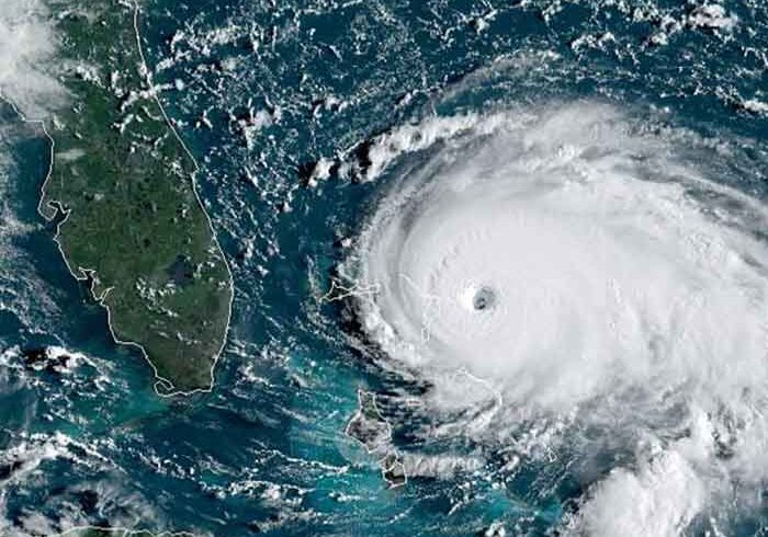
The 2020 Atlantic hurricane season, already busy through early August, could be one of the most active on record, according to an outlook released Wednesday by Colorado State University.
The CSU outlook calls for 24 named storms, 12 of which are expected to become hurricanes, and five of those hurricanes becoming major hurricanes – Category 3 or higher (115-plus-mph winds) on the Saffir-Simpson Hurricane Wind Scale.
If that forecast holds, 2020 would have the second most number of storms in any season, just behind 2005’s 28 storms. It would also tie both 1969 and 2010 for the second most hurricanes in any season, again trailing only 2005’s 15 hurricanes.
CSU’s outlook includes the nine named storms and two hurricanes that have already formed, so they expect another 15 named storms to form through the end of the hurricane season.
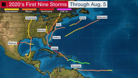
(Data: NOAA/NHC)
If this were to happen, it would use up the entire list of 2020 tropical storm and hurricane names and require use of the Greek alphabet for the remaining named storms. That’s only happened once before in the record-smashing 2005 hurricane season.
During the record-breaking 2005 season, CSU’s August forecast predicted 20 named storms, 10 hurricanes and 6 major hurricanes.
Here are the factors CSU and other seasonal forecasters are keying on for a very active season.
Trending Toward La Niña
El Niño/La Niña, the periodic warming/cooling of the equatorial eastern and central Pacific Ocean, can shift weather patterns over a period of months. Its status is always one factor that’s considered in hurricane season forecasting.
ENSO conditions are expected to remain either neutral – neither El Niño nor La Niña – or trend toward La Niña by fall.
La Niña typically corresponds with a more active hurricane season because the cooler waters of the Eastern Pacific Ocean end up causing less wind shear along with weaker low-level winds in the Caribbean Sea.
In fact, Colorado State University tropical scientist and lead author of seasonal forecasters, Phil Klotzbach, noted that July wind shear over the Caribbean Sea was second lowest in 41 years, behind only the record 2005 hurricane season’s July shear. Wind shear rips apart developing tropical cyclones and can at least disrupt or weaken active tropical storms and hurricanes.
La Niña can also enhance rising motion over the Atlantic Basin, making it easier for storms to develop.
The La Niña years of 2010 and 2011 are among several tied for the third-most-active Atlantic seasons on record. Both years had 19 named storms.
The next La Niña year, 2016, was also active, with 15 named storms that included Category 5 Hurricane Matthew and three other major hurricanes. La Niña conditions developed midway through the hyperactive and catastrophic 2017 season that produced Harvey, Irma and Maria.
Warm Ocean
One of the other ingredients that meteorologists consider in hurricane season outlooks is current sea-surface temperatures across the Atlantic Ocean.
Klotzbach noted that water temperatures between the Lesser Antilles and the west African coast in early August were the fourth warmest since the early 1980s, exceeded only by three notoriously active hurricane seasons: 2005, 2010 and 2017.