


Sarasota County Through the Decades
A Celebration of the County’s Centennial Anniversary brought to you by Planning and Development Services of Sarasota County.
Image credits: Sarasota County Libraries & Historical Resources
Introduction
Sarasota County’s Planning and Development Services (PDS) department has played an important role in the growth and development of the County through broad comprehensive planning efforts which guide future growth and services to ensuring new homes are built to precise, up-to-date safety standards. Learn about some of the key milestones by scrolling through the text and explore the links provided for more information. Through each decade, the corresponding map images show the County’s growth in population and how the pattern of residential development has evolved. (Note: Current city boundaries and road networks are displayed for reference. Additionally, while the maps display county-wide growth and population, the PDS milestones included in this story refer to the unincorporated area of Sarasota County governed by the Sarasota County Commission). Enjoy your journey of Sarasota County’s growth through the decades!
1921
Sarasota County is formed
Sarasota County was officially formed on July 1, 1921 when it separated from Manatee County. At that time, Florida’s land boom was underway and Sarasota County was starting to become a popular vacation and winter destination. The City of Sarasota had already been incorporated in 1913 and most of the County’s scant population was located in or near the city.
1921-1950
Two More Cities Become Incorporated
In 1925, Englewood became the second town in Sarasota County to become incorporated. However, due to the economic hardships from The Great Depression, the town was unincorporated in 1929. The City of Venice incorporated in 1927.
Sarasota County’s Population More Than Doubles Since it was Created
The County’s first official census in 1930 put its population at 12,440 residents. The County grew by nearly 4,000 new residents by its next census in 1940. By mid-century, the County’s population had grown to almost 29,000 residents. Its population was centered primarily in the cities of Sarasota and Venice as well as the community of Englewood. There was also some scattered housing among the keys.
Myakka River State Park Officially Opens
On June 1, 1942, more than 26,000 acres in eastern Sarasota County was officially opened to the public as Myakka River State Park. In the 1930s, after the State of Florida had acquired much of the park land, the Civilian Conservation Corps (CCC) came to Sarasota County to make the land usable as a park. The CCC, established as part of the Depression era New Deal Program, built roads, trails, and bridges, cleared underbrush, and planted thousands of trees. With native materials, the CCC also constructed a visitor center and log cabins which are still in use today.
The Myakka River has been referred to as the “backbone” of our County. Its environmental, geological, and historical significance has made the area a defining feature of Sarasota County. In the decades following the establishment of the Myakka River State Park, the State and local county and city governments have preserved additional lands within the Myakka River Valley to protect it for future generations.
Below is an interactive map of the current public lands within the Myakka River region in eastern Sarasota County. Click on the arrows in the top right corner of the map to access this feature and click the arrows again to minimize it and return to the story. Selecting a polygon will display what year the land was acquired, its acreage, and who the primary owner is. As seen in the subsequent growth maps for each decade, these public lands have a significant impact on the pattern of development in the county, particularly as it progresses west of Interstate 75 to the eastern border.
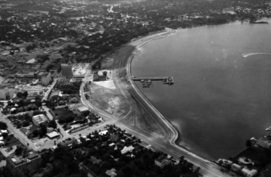
1951-1960
A Post-War Boom Brings New Subdivisions
Like much of the nation, Sarasota County experienced rapid growth following World War II. Subdivisions were laid out throughout the County to handle the influx of new residents and the population more than doubled this decade from 28,827 to 76,895.
- In 1955, Sarasota Springs, a subdivision located off Bee Ridge Road, opened with lots selling for $695 or $10 a month and homes starting at $6,995.
- The new South Venice subdivision sold out its more than 19,000 lots in just a few years at a price of $200 per lot (with a minimum purchase of two lots required).
- The first section of Southgate opened in 1955 from former orange groves into a 1,240-acre subdivision.
- In April of 1956, Kensington Park presented its model homes for buyers to select on one of the 1,400 available lots.
These older subdivisions remain significant today because they provide affordable homes for families. The average square foot of homes built this decade was 1,422 sq. ft. with an average of 2.88 persons per household.
More exclusive subdivisions were also being developed. Some, such as San Remo and Bird Key, were formed by dredging and filling. As the San Remo subdivision was being developed, lot prices started at $3,500 and completed homes were priced from $30,000 to $65,000. Bird Key was marketed as a “jewel in the waters of Sarasota Bay” and boasted an innovative underground electric utility system.
The first shopping center in Sarasota, the Ringling Shopping Center, opened in 1955 and Southgate Shopping Plaza opened later in the 1950s.
Two New Municipalities are Formed
In 1955, the Town of Longboat Key was incorporated and North Port became a city in 1959, bringing the County’s total number of municipalities to four, where it has remained since.
Sarasota County Adopts its First Zoning Code
The FIRST Zoning Code for Sarasota County was adopted in 1955. It consisted of 40 pages and a printed version was available for a price of one dollar. The document outlined the lawful uses and buildings specifications (e.g., maximum height, required open space, etc.) for each zoning district. The Code defined 18 distinct districts including:
- 7 residential districts
- 2 districts for small farms and agriculture
- 1 conservation district
- 3 commercial districts (with one for rural areas)
- 3 industrial districts
- 1 parks district
- 1 interim zoning district to account for unincorporated lands not yet assigned their own code.
The document also contained regulations for:
- Construction and Operation of Mobiles Homes or Trailer Parks
- Construction and Operation of Drive-in Theatres and Outdoor Theatres
- Governing Outdoor Advertising Displays
Updated Zoning Regulations were adopted in 1960. This document established an official zoning map in which the entire unincorporated county was divided into zones, or districts. More detailed descriptions of district standards and the process for requesting changes and appealing decisions were outlined in the new document. The updated Zoning Code also provided sketches to illustrate how structures were to be situated on a property with defined setbacks for public safety and the protection of neighboring property owners.
Sarasota County Water and Navigation Control Authority is Established
The State legislation created the Sarasota County Water and Navigation Control Authority (WNCA) on June 29, 1957 for the initial purpose of regulating dredging and filling operations of navigable waters. Since the establishment of the WNCA, its role has expanded to other permitting activities involving the County’s waterways. Sarasota County’s environmental permitting team has reviewed more than 13,000 applications for shoreline construction such as docks, fishing piers, seawalls, rock revetments, boat lifts, maintenance dredges, etc. Administration of the WNCA Code provides standards to protect property rights, safe navigation, and protection of natural resources. Click here for more information about permitting on Sarasota County’s waterways.
A Comprehensive Plan for the Road Network is Created
In 1960, a vision for the future layout of the roadways in Sarasota County was presented as shown in the map below. At this time, Interstate 75 was in the early planning stages and its location was intended to be much further east than it is was actually built. Development patterns over the years eliminated much of the gridded road network that was envisioned in this plan.
1961-1970
Sarasota County Looks to its Future Growth
Sarasota County continued its rapid growth during the 1960s. The population jumped from 76,895 in 1960 to 120,413 in 1970. Sarasota County responded to its sudden and rapid growth with the adoption of the General Plan in 1968. This document is identified as the Planning Department’s FIRST comprehensive report in the area of general planning and served as the initial step toward developing a formal comprehensive plan. The Plan expressed the following statements and ideas:
- The Plan should be general and flexible to address changing conditions.
- The Plan must have official status, but not be a law or regulation; the intent is to serve as a guide for citizens and public officials.
- The Plan is to be idealistic in nature and to establish the Community’s long range development aspirations.
- The Plan recognizes the importance for coordination with the development effort of the cities within Sarasota County.
- The Plan should promote the concept of “centralized” development around existing core areas to protect existing investment and prevent urban sprawl.
The Plan also defined “the ultimate goal of continuing planning and development” as follows:
“The single ultimate goal of continuing planning and development in Sarasota County shall be the achievement of the highest standards of harmonious design and development to the extent that these standards may be demonstrated to conserve and promote the public’s good health, safety, high morals, order, comfort, convenience, good appearance, prosperity, and general welfare, and as they may be achieved through mutual cooperation and coordination between component jurisdictions of Sarasota County, and its neighboring jurisdictions throughout the greater region, and all as it may accomplished through democratic processes, and in accordance with the law.”
Educational and Retirement Opportunities Expand
The county’s reputation as a premier retirement community was enhanced further with the construction of Plymouth Harbor, a 25-story apartment building designed for retirees. At the time of its completion in 1966, the building was the tallest residential structure in the state and its $4 million building permit was the largest recorded in Sarasota’s history.
Educational opportunities grew with the establishment of New College, and new libraries in Englewood and Venice. An addition was added to Sarasota High School, designed by Paul Rudolph in the Sarasota School of Architecture style.
1971-1980
The Greatest Number of New Residents Arrive this Decade
This decade experienced the largest numerical increase – over 80,000 new residents came to Sarasota County! This time period also showed a significant shift in the population moving further east. The construction of the Tampa to Naples segment of Interstate 75 began in the late 1970s.
Long-range Planning Begins to Take Shape
A supplement to the 1968 General Plan, Policies for Growth, was completed in 1971. This Plan furthered the idea of development that is concentrated around the existing core centers of Sarasota, Venice and Englewood and separated by suburban and semi-urban areas.


As a precursor to the County’s later Comprehensive Plan, many similar elements exist between the two documents. The major plan elements of the 1971 General Plan include:
- Concept for Residential Development
- Concept for Commercial Development
- Industrial Development Concept
- Planning Concept for Open Space
- Planning Concept for Institutional Areas and Public Facilities
- Concept for Planning Transportation Facilities
- Concept for Semi-Urban and Ecological Value Areas
- Planning Concept for New Communities
The General Plan also included more detailed characteristics of each element and how they relate to each other, often illustrated as shown in the example below.
Four Significant Environmental/Planning Acts are Passed
Several new growth management policies were passed by the Florida legislature in 1972 to protect the State’s environmental resources and address its rapid growth.
1. The Florida Environmental Land and Water Management Act
- Created regulatory process for “Developments of Regional Impact”
- Provided for designation of environmentally sensitive “areas of critical state concern”
2. The Florida State Comprehensive Planning Act
- Required the Governor to prepare a State Comprehensive Plan
- Created a Division of State Planning
3. Florida Water Resources Act
- Created regional water management districts
4. The Land Conservation Act
- Authorized State to buy environmentally endangered lands and land for outdoor recreational use
Sarasota County Adopts its First FEMA Floodplain Ordinance
In July of 1971, Sarasota County adopted the FEMA (Federal Emergency Management Administration) Flood Hazard Boundary Maps. This allowed flood insurance to become available to residents in flood hazard areas of the County.
Sarasota County Approves its First Developments of Regional Impact
Following the framework provided in the Florida Land and Water Management Act, the state legislature created a formal process in 1973 to review large-scale developments that may have a significant impact on public infrastructure and greatly increase the demand for public services, including impacts that may be felt by neighboring jurisdictions. These large developments, called DRIs, or Developments of Regional Impact, require approval of a master development plan and are reviewed by state, regional and local agencies. DRIs can take a decade or longer to complete and include:
- Airports
- Attractions
- Hotels
- Industrial plants and parks
- Commercial developments
- Residential developments
- Multi- or mixed-use projects
In 1974, Sarasota Square Mall became the County’s first Development of Regional Impact (DRI) totaling 819,298 square feet with planned phased expansions. Later that year, The Meadows, Sarasota County’s second DRI was approved. The project, taking almost three decades to build out, contained over 1,300 acres, nearly 4,000 dwelling units, a golf course, an adult living facility, and 100,000 square feet of commercial, office and professional uses. Thirteen additional DRIs have been approved over the next several decades with the latest, Villages of Lakewood Ranch South, also known as Waterside, in 2010. Below is an interactive map of the County’s approved DRIs. Click on the arrows in the top right corner of the map to access this feature and click the arrows again to minimize it and return to the story.
Local Governments are Required to Adopt Comprehensive Plans
The State passed the Local Government Comprehensive Planning Act of 1975 which mandated that each local government adopt a comprehensive plan by 1979. Local governments were required to coordinate with state and regional agencies who would also review the plans. The Plans were not required to be adopted by the State and and there was no legal authority to enforce the plan.
Sarasota County Adopts Land Use and Thoroughfare Plans
Sarasota County’s first Land Use Plan was adopted in 1975. A major tenet of the plan focused on the distinction between urban and rural land areas and guiding growth and infrastructure to the urban areas. The future vision was illustrated in the Land Use Plan and Thoroughfare Plan map (shown below). Ten Land Use Designations were defined including a range of residential densities. Areas suited to specific development types were identified (e.g., industrial parks should be located near I-75 interchanges, along interstate connectors, and railroads).
Zoning Regulations Align to the Comprehensive Plan
In 1975, Sarasota County updated the Zoning Regulations along with a countywide update of the zoning classifications assigned to lands. The update supported the goals and objectives of the Comprehensive Plan. It expanded regulations relating to uses allowed in the districts, provided for measure to ensure compatibility between districts by strengthening landscaping requirements and uses within each district. The document established:
- 5 districts related to agricultural and conservation
- 12 residential districts to include single family, multi-family, and manufactured home parks,
- 6 commercial districts with one specifically designated for office, professional and institutional uses
- 3 industrial districts
- 1 government use district
- 1 marine park district (to allow for activities within the waterways.
What Did Your Neighborhood Look Like in 1974?
Jump back to 1974 by exploring the interactive map below.
A View into the Past: Sarasota County 1974 and Today
Use the swipe bar to view how Sarasota County’s landscape has changed from 1974 to 2020.
https://sarco.maps.arcgis.com
1981-1990
Interstate 75 is Completed Furthering Connections in the County
The completion of I-75 in Sarasota County during the 1980s helped to spur growth in the eastern portions of the county, as well as provide additional connection between the cities of North Port and Sarasota.
County Adopts Regulations for Land Development
While the County was continuing to refine its Zoning Regulations and Plans for future growth, regulations that addressed the horizontal construction of developments had not been created. In November of 1981, specifications relating to stormwater, utilities, roadways, access and platting were addressed in the County’s first Land Development Regulations.
Sarasota County Updates its Comprehensive Plan in 1981
The 1981 Comprehensive Plan focused on:
- The establishment of urbans areas to concentrate density and intensity
- Efficient delivery of urban services
- Providing for open space
- Protecting the coastal area
- Retaining agricultural lands
While the General Plan of 1968 recognized three Growth Centers of Sarasota, Venice, and Englewood, the 1981 Plan also included North Port/Warm Mineral Springs, acknowledging the recent and potential growth in these southern portions of the County. The FLU map portrayed Intensity Bands in which higher density would occur near the four Growth Centers, with gradual decreases in density as distance from the core areas increased.
Activity Centers for commercial activity were depicted in red and located at intersections of major roads; industrial sites, known as Major Employment Centers, were shown in purple. Both of these land uses were undefined and intended to depict general locations of these land uses.
Environmental Protections are Enhanced
In 1983, Sarasota County adopted a Tree Protection Code recognizing the importance of protecting the County’s trees amid increasing development pressures. The ordinance established a permitting process for the removal of trees and provided for the protection or relocation of trees during the land development process. Subsequent amendments addressed classification of invasive species, canopy roads, and the protection of Grand Trees.
Also during this decade updates to the Coastal Setback Ordinance were passed. The original ordinance, passed in 1972, established a building setback line from the Gulf of Mexico and, without approval for certain exceptions, prevented any construction seaward of the setback line. The intent of this regulation is to preserve and protect the County’s coastal barrier island Beach and Dune system from imprudent construction, which would jeopardize the stability of the Beach and Dune system, accelerate erosion, provide inadequate protection to upland properties and endanger adjacent properties. In 1986, the Barrier Island Pass 20-year Hazard Line was delineated and defined similar standards for the Big Sarasota Pass Shoreline. In 1989, the Gulf Beach Setback Line was redefined based on the anticipated impacts of the 100-year storm event.
Sarasota County Focuses on Planning for Smaller Areas
The small area or Critical Area Planning (CAP) program began in 1984 and was originally called the Sector Plan Program. The first CAP was adopted for the intersection of Bee Ridge and Cattlemen Roads, and the County has since adopted more than 30 CAPs. These plans were initially used to define the location and limits of commercial and industrial development and evolved into planning for a variety of areas such as the historic communities of Englewood and Nokomis or expanding roadway corridors such as Fruitville Road or State Road 776. The CAPs plan for development and redevelopment issues that are not addressed in County-wide development regulations but are important to smaller geographic areas.

Comprehensive Planning in Florida is Redefined
In 1985, the State passed the Local Government Comprehensive Planning and Land Development Regulation Act, sometimes referred to as the Growth Management Act. This new Comprehensive Planning Act included significant updates to the original 1975 Act including:
- Local plans and amendments must be adopted by ordinance and also reviewed and approved by the State, providing for the legal status of the plans.
- Plans must have a future land use map and a capital improvements element and show financial feasibility.
- Creation of a detailed review process with local, state and regional input, formal processes for challenges, and sanctions for noncompliance through the establishment of administrative rule (9J-5).
- Requirement that local governments also adopt Land Development Regulations.
The passage of the new comprehensive planning requirements spurred an update to the County’s comprehensive plan and the adopted of a new Future Land Use Map shown below.
1991-2000
Sarasota County’s Beaches Attract More Than Just Tourists
Sarasota County’s beaches have the highest concentration of loggerhead sea turtle nests on the Gulf Coast! Loggerheads are a threatened species and in 1997, Sarasota County adopted the Marine Turtle Protection Ordinance to help our visiting turtles. The ordinance is designed to protect nesting and hatching sea turtles from artificial light and obstructions on the beach during nesting season (May 1 through October 31). Artificial light draws turtles away from the water, which can lead to injury or death.
The Revitalization of Englewood Begins

In 1998, The Englewood Community Redevelopment Area (CRA) was established by the Sarasota County Commission. The CRA was challenged to create a plan for revitalizing a deteriorating downtown while respecting its history and maintaining its treasured small-town atmosphere. The following year, the Englewood Redevelopment Plan was adopted and funding for implementing the Plan was secured through a Tax Increment Financing district. Learn more about Englewood’s history and the many projects the County’s CRA program has contributed to the community by exploring the link below.
The Englewood Community Redevelopment Area
The Englewood CRA story map is an interactive map journal providing a brief history of the area and the CRA program, highlights of successful CRA projects, upcoming projects, and information about CRA sponsored community events.
https://sarco.maps.arcgis.com
Sarasota County Recognized as Tree City USA
Sarasota County understands how healthy trees contribute to a healthier community. Trees are assets to a community when properly planted and maintained. They help to improve the visual appeal of a neighborhood, increase property values, reduce home cooling costs, remove air pollutants and provide wildlife habitat and provide many other benefits. Due to the County’s efforts in protecting trees, including the 1983 adoption of the Tree Protection Code, Sarasota County achieved Tree City USA recognition in 1991 by meeting the program’s four requirements: (1) a tree board or department; (2) a tree-care ordinance; (3) an annual community forestry budget of at least $2 per capita; and (4) an Arbor Day observance and proclamation. As noted by Dan Lambe, the president of the Arbor Day Foundation:
“Tree City USA communities see the impact an urban forest has in a community first-hand. The trees being planted and cared for by Sarasota County are ensuring that generations to come will enjoy a better quality of life…this program brings residents together and creates a sense of civic pride, whether it’s through volunteer engagement or public education.”

Sarasota County has achieved Tree City USA recognition every year since 1991. The Tree City USA program is sponsored by the Arbor Day Foundation in partnership with the U.S. Forest Service and the National Association of State Foresters. More information regarding this program is available at this website.
A New (or Old?) Purpose for the Celery Fields
In 1992, Sarasota County experienced a significant flooding event when Phillippi Creek spilled into surrounding neighborhoods and damaged multiple structures. The County looked to solutions upstream to prevent future flooding and thus created the Celery Fields Stormwater Retention Facility. While the area is more commonly known for its agricultural significance in the production of celery crops, early settlers found the area seasonably swampy and covered in inhospitable sawgrass. In 1921, the Sarasota-Fruitville Drainage District was formed to create a drainage plan for the area. Canals were dug and much of the remaining muck land was found to be ideal for growing celery.
While the Celery Fields made Sarasota one of the largest celery-exporting areas of the state, it came with a cost. Draining the land allowed stormwater to flow too quickly through the Phillippi Creek watershed. The major flooding event in 1992 prompted the County to purchase the Celery Fields in 1995 to manage flood waters downstream, and in a sense, restored the area to its original function for holding excess stormwater. No major flood events have occurred since the creation of the Stormwater Retention Facility.
Today, the 360-acre Celery Fields operates as a flood control facility with a variety of recreational amenities. It is also home to Sarasota Audubon Society’s Nature Center and a popular birding hot-spot on the Great Florida Birding Trail with over 200 bird species documented to date. Visitors can spot wildlife from the boardwalks and trail around the restored wetlands. The mound (“Mount Celery”) is popular among fitness enthusiasts who are often seen walking or running the climb to its summit and enjoying the views.

Urban Service Boundary is Added to the FLU Map
In 1996, the Future Land Use Map included a new feature, the Urban Service Boundary (USB). The USB was added to help ensure that County funding for capital improvements would continue to be spent within the areas designated for urban uses. Several new land use categories were also created, including Town and Village Centers, which were designed to promote redevelopment, and boundaries of Major Employment Centers and Commercial Centers were delineated.
Residents Participate in Community Planning Efforts
Also in 1996, the County officially began its Community Planning Program designed to take a holistic planning approach to improving existing communities through the establishment of Neighborhood Conservation Districts and by investigating land use, transportation, recreation, and public facilities issues. The Community Planning program was the first County planning program that depended on community involvement. Some outcomes of these early Community Plans include:
- Safer routes to schools and crosswalk improvements (Bee Ridge Community Plan)
- Funding allocations towards park and streetscape improvements (Siesta Key Community Plan)

A Unique Geologic Feature is Protected
At the southern end of Crescent Beach on Siesta Key, for approximately one-half mile, is a series of rock formations that extend into the Gulf of Mexico nearly 100 yards off-shore. This unique formation of beach rock that formed over thousands of years, is known as Point of Rocks; and it is the only such rock formation on the west coast of Florida. Snorkeling and diving are popular here in the shallow, clear waters where a variety of sea life lives among the rocks. For those walking, low tide exposes the rock formations and also allows for exploration of sea life in the tidal waters.
Recognizing the significance of this unique area, Sarasota County adopted an ordinance in 1993 protecting the live rock located at Point of Rocks. The ordinance establishes that damage or destruction of the rock is a violation and fines and penalties can be enacted.

2001-2010
The Real Estate Bubble Drives Rapid Growth
The early part of this decade can be defined by the real estate bubble that impacted the entire country to some degree. Sarasota County experienced rapid development during the first half of the decade, growing its population by 12%. During this time, the median sales price of single family homes in the county increased by 92%.
The need for more affordable housing pushed many residents into the City of North Port where younger families and less affluent retirees could attain more affordable homes. As a result, North Port’s population more than doubled during this decade.
Following 2005, however, the real estate bubble burst, growth slowed in the County, and many large developments went idle. The median sales price of homes fell and population only grew by 5%, compared to 12% during the first half of the decade.
Cities Change Shape
As population growth expanded during the first half of the decade, city boundaries were expanding as well. For a period of six years, beginning in 2000, the cities of North Port and Venice underwent a series of annexations that significantly increased their sizes. Through the annexations of several enclaves and large tracts of land east of the interstate, the City of Venice added nearly 5,000 acres and increased its size by 85%. As depicted in the Sarasota County 1989 Future Land Use Map, much of the newly annexed lands east of the interstate had been designated as Major Employment Center. Currently, the land is being developed primarily for residential uses within the City of Venice, which can be seen in the 2010 and 2020 growth maps.

The City of North Port grew almost 40% by annexing nearly 18,900 acres. The annexed land to the west of the City became the West Villages Improvement District, also known as Wellen Park. The historic Warm Mineral Springs was also annexed into the City of North Port during this decade. A significant portion (5,776 acres) of the annexed area in the northeast is now part of the Orange Hammock Wildlife Management Area (OHWMA) acquired in 2020 under the Florida Forever Program with funding from the Conservation Foundation of the Gulf Coast. The OHWMA represents the largest undeveloped parcel of land in Sarasota County and is part of a 121,000+ acre conservation corridor that protects environmentally sensitive land between the Peace and Myakka Rivers and Charlotte Harbor.

A New Plan for Growth is Adopted
As remaining capacity became more strained within the urban service area, Sarasota County looked to alternative forms of development outside the urban service boundary that could accommodate future projected growth while also preserving important environmental and agricultural lands and maintaining a sense of rurality. The beginning of this decade saw the adoption of the Sarasota 2050 Plan, which provides the option for higher density developments in rural/semi-rural lands out east in exchange for preservation of open space and greenways. The Plan also addressed land uses in the urban service area with policies aimed at strengthening neighborhoods and encouraging redevelopment. The 2050 Plan produced an optional overlay to the Future Land Use Map which divided the unincorporated county into Resource Management Areas (RMAs). Due to the Great Recession in the later part of the decade, the development of the 2050 projects out east would not begin until the following decade.

Sarasota County Takes Steps to Protects Its Water and Shorelines
In 2001, Sarasota County adopted its Water Efficient Landscaping ordinance to promote conservation of water resources. The ordinance requires resourceful landscaping planning and installation as well as efficient water irrigation and maintenance measures.
The County’s first comprehensive shore protection project, South Siesta Key Beach Restoration, was completed in 2006. This project spanned 2.1 miles along South Siesta Key Beach. A total of 922,300 cubic yards of sand was placed upon the shore.
In 2008, the County adopted the FIRST ordinance in the State targeted at improving our water quality through the proper application of fertilizers.

A Statewide Building Code is Adopted
In the 1970s, Florida passed a law requiring all local governments to adopt and enforce building regulations based on the minimum standards to ensure the public’s health and safety. This resulted in inconsistent standards across jurisdictions, and following the widespread devastation caused by Hurricane Andrew in 1992, revealed deficiencies when faced with wind storm events. A comprehensive review of the building codes system by the State recommended a regulatory system based on uniformity and accountability. Thus, in 2002, the Florida Building Code became effective and superseded all local building codes. The Florida Building Code, updated every three years and enforced by local governments, regulates the design, construction, alteration, modification, repair, and demolition of public and private buildings and structures in the state.

Additional Protections are Adopted for our Marine Life
The State of Florida has designated 13 counties as a priority protection site for manatees and requires these counties to develop a Manatee Protection Plan (MPP). In 2003, Sarasota County adopted its first Plan designed to reduce the likelihood of boat-manatee interactions. (The most recent Plan update occurred in 2011). Manatees are classified as an endangered species and are often spotted in our local waters.

Sarasota County Neighborhoods Gain New Focus
Two new programs benefiting neighborhoods launched this decade. In 2002, Sarasota County launched its popular Neighborhood Initiative Grant Program (NIGP). The program goals are to preserve and enhance neighborhoods by providing opportunities for communities to identify areas for improvement, and to strengthen the community through collaboration and volunteering. The NIGP is a competitive 50/50 matching grant program. Neighborhoods can provide their 50 percent of their match through cash, donations, or volunteer hours credited at $20 per hour. Projects must meet at least one of the five themes:
- Character – “Place-making” through the creation or enhancement of assets that are a source of neighborhood pride and identity.
- Leadership – Training neighborhood leaders or teams, and developing skills for neighborhood governance or action.
- Safety – Equipping the neighborhood with knowledge or tools to prevent, prepare for, or respond to incidences or crime, danger, or disaster.
- Environment – Protecting water and energy resources, and native plants and animals
- Health – Increasing access to nutritious diets, physical or mental fitness opportunities, or health education.
Since its inception, the County has helped improve dozens of neighborhoods with this program. The image below contains some “before and after” photos of just two of the neighborhoods that have been enhanced through this program.

A decade after the Community Planning program was founded, the Neighborhood Planning program was developed. Smaller in scope, Neighborhood Plans were designed to be a more direct approach to address infrastructure and code deficiencies. One of the first Neighborhood Plans to be adopted was Pinecraft in 2004, which involved a significant streetscaping project for Bahia Vista Street and improvements to Pinecraft Park. The Laurel Neighborhood Plan, completed in 2005, resulted in a waterline extension, improvements to the Community Park and addressed walkability with enhanced sidewalks.
Following a series of community building and strengthening exercises with County staff from 2008-2010, residents from the aging Kensington Park neighborhood requested several priority issues to be addressed by the County. (Recall Kensington Park was one of the multiple post-war boom developments that sprang up in Sarasota County). The issues were later addressed in its Neighborhood Plan and included: Code Enforcement, Crime and Safety, Transportation, Utilities, Appearance and Beautification, and Community Building. Improvements and projects as a result of the Neighborhood Planning process included:
- installation of stop signs at various intersections
- improvements to the nearby school zone
- enhanced landscaping near neighborhood entrance signs
- creation of a neighborhood park
County Overhauls Zoning Regulations
In 2003, Sarasota County performed an overhaul on the Zoning Regulations, further providing clarification for development standards for each zone district and providing a “use table” for ease of locating permissible uses within each district, ensuring adherence to the County’s Goals and Objectives of The Comprehensive Plan. This update expanded zone districts previously established with the 1975 Code and added special Overlay Districts as well as districts that would allow for the sending and receiving of residential density. It also provided development standards for each district in a concise table for ease of use.

Sarasota County Adopts Code to Keep the Myakka River “Wild and Scenic”
The Myakka River has been a state-designated “Wild and Scenic River” throughout Sarasota County since 1985. The river is recognized as a valuable environmental resource in our community. As such, the County adopted the Myakka River Protection Code in 2003 (with an amendment in 2008) that is applicable to all properties within 220 feet of the Myakka River Area. The primary goal of Myakka River Protection Code is to continue to facilitate protection of the wild and scenic character of the river while maintaining livability along the river for its neighbors. Coupled with the acquisitions of the Environmentally Sensitive Land Protection Program, as well as state-owned lands with the watershed, the Myakka River will remain one of the top environmental destinations in our County for wildlife viewing, recreation, and to experience a bit of that old Florida charm.


2011-2020
New Patterns of Development Emerge
The first Sarasota 2050 Village development that was approved, Villages of Lakewood Ranch South, began construction. Another 2050 development, Grand Palm, is approaching buildout. North Port’s West Villages, which started building in the previous decade, has seen significant growth. Residential activity is also occurring in the forms of infill and redevelopment. South Venice and North Port are seeing new homes built on older platted lots. The cities of Venice and Sarasota are seeing redevelopments of older homes or commercial structures converted into larger homes or higher density residential projects.
The New Unified Development Code is Adopted
In an effort to better align the County’s Comprehensive Pan with its Zoning Regulations and Land Development Regulations (LDRs), a new Unified Development Code (UDC) was created. Combining the Zoning Regulations and LDRs provided clarification and removed inconsistencies between the two documents and the Comprehensive Plan, while also addressing those provisions that had become obsolete. The significant update created a new new document that is easier to read, understand, and interpret by all users. It also organized significant regulatory information applicable to a specific zoning district in a single location. The UDC became effective on January 1, 2019.
Manasota Key Beach is Restored
Working in partnership with Charlotte County, the beach along Manasota Key, from just north of Blind Pass Beach Park to just north of Stump Pass, was restored using sand dredged from offshore borrow areas. The Sarasota County portion of the project received approximately 301,680 cubic yards of sand in two areas spanning a total of 1.6 miles. The project also helped in the repair of Manasota Beach Road at Blind Pass Beach Park which had been damaged due to storm-related erosion of the beach.


Sarasota County Focuses on Unlicensed Contractors
Unlicensed contractors can be hazardous to the health, safety and welfare of homeowners. Hiring unlicensed contractors can also result in greater costs in the long run. In an effort to protect its citizens, Sarasota County created the Licensing Enforcement Team in 2014 to deal directly with unlicensed contracting and unpermitted work. The following year, a multi-agency and multi-jurisdictional task force was created to further address the illegal activity. These efforts have resulted in multiple benefits for the County’s residents including:
- Public outreach efforts to inform the public including attendance at multiple home shows
- Issuance of 690 citations from 2014 to 2020 for unlicensed activity
- Collaboration with crimestoppers to respond to anonymous complaints
- Coordination with the Sheriff Department in multiple sting operations from 2014 to 2019. (One sting operation in 2014, called Operation Freelancer, resulted in 14 felony charges, 36 misdemeanor charges and 3 citations).


2021 – Happy 100th Birthday Sarasota County!
Sarasota County’s Planning and Development Services Continues to Plan for the Future
The nature of planning and how it is performed in Sarasota County is evolving as the patterns of growth are shifting. New opportunities and challenges will likely be presented. Larger multi-use developments are occurring in the eastern portion of the County and more complicated redevelopment and infill projects are occurring in the urban areas. Here are a few of the projects that Sarasota County’s Planning and Development Services will be focused on:
- 2050 Villages
- Affordable Housing
- Critical Area Plans
- Redevelopment and Infill
- Neighborhood Plans
- Mixed Use Developments
Sarasota County’s Planning and Development Services department will continue working to help ensure our residents enjoy our high quality of life for the next 100 years!

For additional information regarding this StoryMap, please contact Sarasota County Planning and Development Services at 941.861.5000 or at planner@scgov.net.